Synopsis:
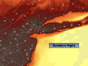
Our Summer preview will continue through the weekend as a Bermuda high dominates. It’ll be a sizzlin’ Sunday with readings most likely getting up to the hottest levels so far this year. Readings will top 90º. An isolated thunderstorm is possible by evening with an approaching cool front but unfortunately most areas will remain rain-free. Yes, we desperately need the rain. It’s been two weeks since we had any precipitation.
Relief will arrive on Monday behind the cool front. It’ll be much cooler with readings staying below the average high of 73º. It will feel refreshing.
On Tuesday temperatures will begin their upward climb once again. By Wednesday, readings once again we feel like a day out of July. The warm weather will stick into Thursday under a mix of sun and clouds.
Keep it here for a no nonsense, no hype forecast.
Today:
Mostly sunny and hot. Highs around 90º. Northwest winds at 10-20mph.
Tonight:
An isolated evening storm, otherwise partly cloudy and much cooler. Lows around 60º in urban areas, the 50s inland. Northeast winds at 8-12mph.
Monday:
Sunny. Much cooler. Highs in the the upper 60s to lower 70s.
Tuesday:
Mostly sunny. Highs in the upper 70s.
Wednesday:
Partly sunny and very warm. Highs in the upper 80s to around 90º.
Thursday:
Mostly sunny. Warm. Highs in the mid 80s.