Synopsis:
A weak impulse will move off the coast tonight and Wednesday. Moisture from the East will result in a chance of scattered rain, snow or sleet showers depending on location. A bit of freezing drizzle may fall as well. Some areas will remain precipitation free. Isolated slick spots are possible North and West.
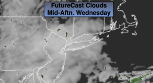
Much of Wednesday-St. Patrick’s Day will be grey but dry. Readings will be close the the average high of the upper 40s.
A more signifiant area of low pressure will develop over the central Appalachians on Thursday. Rain will move in during the late morning and midday hours. The latest computer guidance takes the low off the Delaware coast. With the low this close a round of moderate to heavy rain is likely later in the day and at night.
Canadian high pressure will bringing in colder air as the low moves off the coast Friday. Depending on where the precipitation shield sets up any rain could mix with and possibly change to wet snow for at time. The best chance of snow is North of the City. There is a potential of accumulating snow in this area. Central and Southern areas will mainly be rain. As the storm pulls out to sea the precipitation will come to an end later Friday morning into the midday hours. Some afternoon sun is possible.
Saturday Spring arrives. The sun will shine as we turn the page to the new season. Readings will be near the average high for the day.
Sunday will be bright and mild as a large high pressure system sits over the Northeast.
Stay Tuned.
Keep it here for a no nonsense, no hype forecast.
Tonight:
Areas of showers, light freezing drizzle, light snow or sleet possible depending on your temperature. Lows will be in the mid 30s in the City, near 30º well inland. Southeast to East winds at 5mph.
St. Patrick’s Day:
Mostly cloudy. Highs in the mid to upper 40s. Northeast to East winds at 5mph.
Thursday:
Thickening clouds. Rain likely by midday. The rain will become heavy at times late. Highs around 50º.
Friday:
Rain. Potential of wet snow North. Precipitation will taper off around midday. Afternoon sun is possible. Colder. Highs in the lower 40s.
Saturday:
Sunny. Highs in the mid to upper 40s.
Sunday:
Sunny. Milder. Highs in the mid 50s.