Synopsis:
A quick hitting Arctic blast will be with us during the morning. Readings will be well below freezing and the wind will be like a slap in the face. Wind chills will be in the single digits and teens.
Sunny and cold conditions are expected for today as high pressure moves overhead. Highs will be just above freezing, but thankfully the winds will diminish by afternoon.
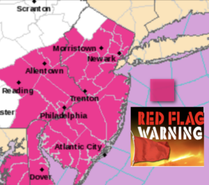
A Red Flag Warning has been issued for much of NJ today. Dry ground, low humidity levels and gusty winds will promote the growth of wild fires. Please use caution while outdoors while using flammables.
Tonight will be clear, calm and cold with high pressure overhead.
A weak impulse will move out of the central Appalachians and toward the region later Tuesday. This system will be moisture starved. Any sun will give way to increasing clouds. The impulse will move off the coast Tuesday night and Wednesday. Moisture from the East will result rain and or snow showers during this time. The sun should return later in the day Wednesday.
A more signifiant area of low pressure will develop over the central Appalachians on Thursday. Any morning sun will give way to thickening clouds. Showers are possible by late day. The latest computer guidance now takes the low off the Maryland coast. With this Southern trend colder air will filter into the region on Friday. Depending on where the precipitation shield sets up any rain could mix with and possibly change to wet snow for at time. Again, this depends how far North the shield of precipitation gets.
Stay Tuned.
Keep it here for a no nonsense, no hype forecast.
Today:
Mostly sunny. Cold. Highs in the mid 30s. Northwest winds at 15-25mph with gusts to 30mph in the morning then diminishing to 10-15mph by afternoon.
Tonight:
Clear and cold. Lows in the mid 20s along the coast, the teens inland.Northwest to Northeast winds at 5mph.
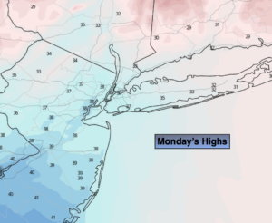
Tuesday:
Early sun, otherwise becoming mostly cloudy. Highs in the lower 40s.
Wednesday:
Scattered morning showers (wet snow showers well inland). Some afternoon sun. Highs in the mid 40s.
Thursday:
Thickening clouds. Showers likely during the afternoon. Highs around 50º.
Friday:
Rain or a mix of rain and wet snow possible. Colder. Highs in the lower 40s.