Synopsis:
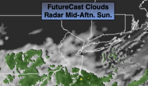
It’ll feel like a different season today as readings will be well below average. Saturday temperatures were around 70º, today we’ll only be in the lower to mid 50s. Any sun will give way to increasing clouds. Scattered showers are possible later in the day especially from the City and to the South as moisture rides North from a weak disturbance.
Scattered showers are likely tonight into Monday as low pressure moves off the North Carolina coast.
Tuesday and Wednesday will feature a cool front just to our North and West. This front will washout and lose much of its moisture. A few showers are possible Tuesday. Clouds will dominate but the sun should make an appearance, especially by Wednesday. Temperatures will be near the average high of 60º.
Tropical system Zeta will make landfall over the Northern Gulf coast states midweek. This remnants will move up the Piedmont and result in a rainy day on Thursday.
Stay Tuned.
Keep it here for a no nonsense, no hype forecast.
Today:
Any morning sun will give way to clouds. Scattered late afternoon showers are possible, especially South of the City. Much cooler. Highs in the lower to mid 50s. Northeast winds at 8-12mph.
Tonight:
Cloudy with scattered showers. Lows in the 40s throughout. Northeast winds at 8-12mph.
Monday:
Cloudy with scattered showers. Highs in the upper 50s.
Tuesday:
Mostly cloudy. A spot shower possible. Highs around 60º.
Wednesday:
Clouds and sun. Highs in the upper 50s.
Thursday:
Rain likely. Highs around 60º.