
Synopsis:
High pressure will over the Southeast will result in a bright, warm and comfortable getaway day Friday. Readings will be several degrees above the average high of 80º.
A weak cool front will move through tonight. It will come through uneventful.
At this time it looks like we’ll take 2 out of 3 days for the Labor Day Holiday Weekend. High pressure will build in from the North Saturday and Sunday. The sun will dominate with near seasonal temperatures. A few more clouds are expected on Sunday. On Labor Day Monday a cool front will approach. There is a chance of scattered showers. It doesn’t look like a washout.
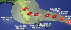
Hurricane Dorian continues to move Northwest in the Atlantic. Dorian is forecast to become a major hurricane- category 4 status with sustained winds of 140mph by this late this weekend and into Labor Day . The computer models have slowed the hurricane considerably by the weekend into Monday as a strong ridge of high pressure over the Western Atlantic and steers the Hurricane West (2nd map above). Where the Dorian makes landfall is not known at this time. The concern is with the slow movement (basically a crawl) some areas of Florida will have a prolonged time of very dangerous conditions. Is it possible that the storm stays just off the coast before the North turn? Yes. But this solution right now is the outlier. Please do not concentrate on the exact track, but rather on the yellow cone of uncertainty.
Stay Tuned.
Keep it here for a no nonsense, no hype forecast.
Today:
Sunny, warm. Highs in the mid 80s. Southwest winds at 8-12mph.
Tonight:
Clear and comfortable. Lows in the mid 60s in the City, the 50s inland. Northwest to North winds at 5-10mph.
Saturday:
Mostly sunny. Highs lower 80s.
Sunday:
Sun & clouds. Highs in the upper 70s.
Labor Day:
More clouds than sun. Scattered showers possible. Highs around 80º.
Tuesday:
Partly sunny and warm. Highs in the lower to mid 80s.