Synopsis:
Scattered showers will move through the region this evening as a weak front moves in from the West. Skies will clear after midnight and humidity levels will drop by morning.
High pressure will build in from the Tennessee Valley Thursday and Friday. Bright, warm but less humid days are expected. A cool front will move through Friday night.
At this time it looks like we’ll take 2 out of 3 days for the Labor Day Holiday Weekend. High pressure will build in from the North Saturday and Sunday. The sun will dominate with near seasonal temperatures. On Labor Day Monday a cool front will approach. There is a chance of scattered showers. It doesn’t look like a washout.
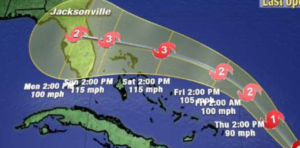
Hurricane Dorian continues to move away from the islands of the Northeast Caribbean. Dorian is expected to become a major hurricane- category 3 status with sustained winds of 115mph by this weekend. The computer models take the storm into Florida late Sunday as a strong ridge of high pressure develops over the Western Atlantic and steers the Hurricane West (2nd map above). Please do not concentrate on the exact track, but rather on the yellow cone of uncertainty.
Stay Tuned.
Keep it here for a no nonsense, no hype forecast.
Tonight:
Scattered showers early. Clearing skies after midnight. Lows in the mid to upper 60s in the City, the upper 50s inland. Winds becoming Northwest at 5-10mph.
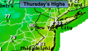
Thursday:
Mostly sunny, warm and less humid. Highs in the lower to mid 80s. Northwest winds at 8-12mph.
Friday:
Mostly sunny, warm. Highs in the mid 80s.
Saturday:
Mostly sunny. Highs lower 80s.
Sunday:
Sun & clouds. Highs in the upper 70s.
Labor Day:
More clouds than sun. Scattered showers possible. Highs in the upper 70s.