Synopsis:
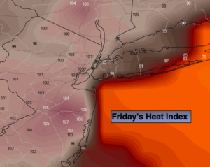
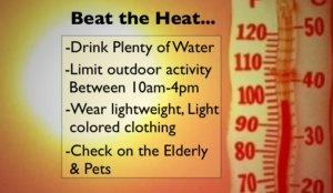
An Excessive Heat Warning is in effect for the entire tri-state area through Sunday as a heatwave grips the area. A Bermuda high pressure is to blame, not your local weather guy. The combination of high temperatures and humidity will result in a heat index of 100º-115º through Sunday. A heatwave is defined as three consecutive days at 90º or above. Actual Temperatures will flirt with 100º in many areas this weekend. The humidity will be high. Please use the above suggestions to “beat the heat”.
The heatwave should break on Monday as a cool front works through with scattered showers and storms.
Stay tuned.
Keep it here for a no nonsense, no hype forecast.
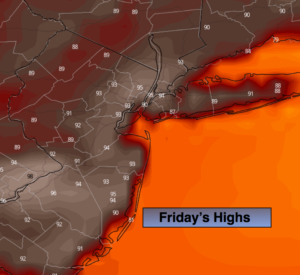
Today:
Becoming hazy, hot and humid. Highs in the lower to mid 90s. Heat index 98º to 105º.
Tonight:
Partly cloudy, very warm and muggy. A stray thunderstorm is possible. Lows around 80º in urban areas, the 70s elsewhere. West winds at 5mph.
Saturday:
Hazy, hot and humid. Highs 95º-100º. Heat index 100º to 115º.
Sunday:
Hazy, hot and humid. Highs 95º-100º. Heat index 100º to 115º.
Monday:
Hazy, warm and humid. Scattered showers and storms possible. Highs in the mid 80s.
Tuesday:
Partly sunny, much less humid. Highs in the mid 80s.