Synopsis:
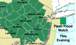
The threat of severe weather continues to diminish this evening. Central & Souther NJ will still be under the gun through mid-evening. The impulse that rode along the front has weaken. The heavy rain will begin to diminish as well. The Flash Flood Watch will likely be canceled later this evening. Until then, please don’t drive through flooded roadways. You don’t know how deep the water is. Turn around, don’t drown.
A mix of cloud and sun is be expected for Thursday. Showers and storms are once again possible with in the afternoon and evening with an approaching cool front.
The front will move through Thursday night and bring an end to the storm threat. Friday and Saturday will be rain-free with the sun dominating. There is a chance of shower on Sunday.
Keep it here for a no nonsense, no hype forecast.
Stay tuned.
Tonight:
Showers and storms with torrential rain will end later this evening, otherwise becoming partly cloudy. Lows in lower 60s in the City, the upper 50s inland. Light and variable winds.
Thursday:
Sun and clouds. Scattered afternoon storms possible. Highs in the lower to mid 70s.
Friday:
Mostly sunny, less humid. Highs in the upper 70s.
Saturday:
Partly sunny. Highs around 80º.
Sunday:
More clouds. A chance of showers. Highs in the mid 70s.
Monday:
Party sunny. Highs in the lower 70s.