Synopsis:
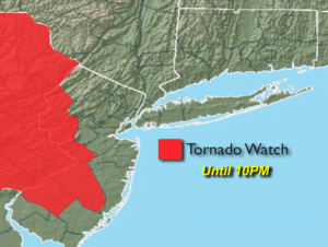
***Tornado Watch until 10pm for Warren, Hunterdon and Mercer counties***
A warm front dividing the tri-state area this evening into tonight will be the focus mechanism for scattered severe thunderstorms. Severe thunderstorms have at least one of the following criteria: winds in excess of 58mph and or one inch hail. Some of the storms may produce an isolated tornado. A Tornado Watch means just that -we’re watching the situation. A warning means that the severe thunderstorm may contain a tornado. Torrential rain and frequent cloud to ground lightning will accompany the storms. Please keep an eye to the sky for threatening weather and take shelter immediately. This front will stick around until Thursday night. When the front slips to the North it will be quite warm and when it slips to the South readings will be comfortable. When this transition happens a spotty pm shower or storm cannot be ruled out through Thursday. By no means will it be a washout. A mix of sun and clouds is expected.
A cool front will move through Thursday night with showers and storms. Friday and Saturday will be rain-free with the sun dominating. There is a chance of shower on Sunday.
Keep it here for a no nonsense, no hype forecast.
Stay tuned.
Rest of today Into This Evening:
Scattered storms will develop later this afternoon and into the evening. Some of the storms may become severe, especially inland. It’ll be warm and humid to the South of the city and much cooler to the North and East.
Tonight:
Scattered strong to severe storms early, otherwise becoming partly cloudy. Lows in lower 60s throughout. Northwest winds at 5mph.
Wednesday:
Partly sunny, seasonal. Chance of a scattered PM showers or storms. Highs in the mid 70s.
Thursday:
Partly sunny, warm and humid. Scattered afternoon storms possible. Highs around 80º.
Friday:
Mostly sunny, less humid. Highs in the mid 70s.
Saturday:
Partly sunny. Highs in the mid to upper 70s.
Sunday:
More clouds. A chance of showers. Highs in the mid 70s.