Synopsis:
Strong high pressure over Southern Canada will influence our weather today. Abundant sunshine and cold readings is expected.
Skies will become mostly cloudy overnight. Lows will be in the mid 20s in the City, the teens inland.
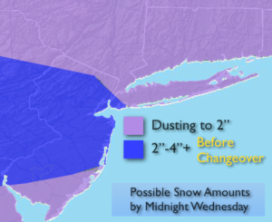
The next system will move out of the Southern states and head Northeast Wednesday. At this time, there is a potential for snow or a mix South starting around midday Wednesday West of the City. It will take until the afternoon hours to reach Eastern sections.
Like so many times this season we’ll be losing cold high pressure to a mild Southerly flow. The snow will turn to a mix and then rain Wednesday night. Before the changeover late Wednesday there’s the potential for a few inches of snow. As of now, the jackpot zone for snow looks to be Western areas. This is for two reasons: 1) It’ll take a while for the snow to overcome the dry air over Eastern sections and 2) by the time the snow gets to that area warm air will already be working up. It won’t be snowing that long. The PM commute is the one to watch with treacherous conditions likely.
A light mix to rain is expected Wednesday night into Thursday morning as the low moves off the New England coast. High on Thursday will spike into the 50s.
More seasonal temperatures are expected Friday and Saturday. It’ll be mainly sunny.
Keep it here for a no nonsense, no hype forecast.
Today:
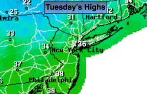
Sunny. Highs in the mid 30s. Northwest winds at 5-10mph.
Tonight:
Partly cloudy. Lows in the mid 20s in the City, the teens inland. Northwest to North winds at 5mph.
Wednesday:
Snow, mix South developing by midday. Snow will reach Eastern areas later in the afternoon. Highs in the mid 30s.
Thursday:
Morning light rain, otherwise becoming partly sunny. Mild. Highs in the mid 50s.
Friday:
Mostly sunny. Highs in the mid 40s.
Saturday:
Partly sunny. Highs in the mid 40s.