Synopsis:
A weak system sliding to our South will cause snow showers over Central & Southern NJ into this evening. A coating of snow is possible over Ocean county. Skies will clear out tonight and it won’t be as nearly as frigid as recent nights as the Arctic airmass loses it grip over the region.
The airmass will slowly moderate as another high works in from the West for the weekend. We’ll be all waiting on the edge of our seat to see if Punxsutawney Phil see’s his shadow on Saturday, Ground Hog Day. By Sunday it’ll feel like a heatwave as temperatures reach the mid 40s! Both days will feature plenty of sunshine.
Taking a peek at next week, the thaw continues through midweek with readings getting into the 50s.
There are indications that a stationary front will be draped from the Mid-Atlantic to the Ohio Valley late next week. Arctic high pressure will be over Eastern Canada. How much colder air interacts with the system will determine what type of precipitation falls.
You know where to find a no hype, no nonsense forecast.
Stay tuned.
Tonight:
Early snow showers South, otherwise becoming partly cloudy and not as bitter as recent nights. Lows around 20º in the City. The single digits inland. West to Northwest winds at 5mph.
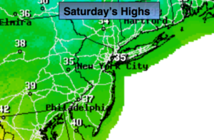
Saturday:
Mostly sunny and not as harsh Highs in the mid 30s. Southwest winds at 5-10mph.
Sunday:
Sunny and mild. Highs in the mid 40s.
Monday:
Partly sunny and mild. Highs near 50º.
Tuesday:
Clouds and sun. Spotty showers. Balmy. Highs in the mid 50s.
Wednesday:
Partly sunny, cooler. Highs in the mid 40s.