Synopsis:
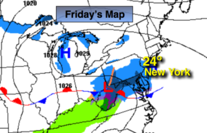
Arctic high pressure will slowly lose its grip over the region by late today. But, until then, it will be frigid around these parts. Mostly cloudy skies are expected for February’s debut as a weak system passes to our South. This system may spark a few snow showers mainly South of the City today. Over Ocean county a coating of snow is possible. Highs will reach the lower to mid 20s.
The airmass will slowly moderate as another high works in from the West for the weekend. This system will not be accompanied by bitter readings. Skies will be mainly sunny. By Sunday it’ll feel like a heatwave as temperatures reach the mid 40s!
Taking a peek at next week, the thaw continues through midweek with readings getting into the 50s.
You know where to find a no hype, no nonsense forecast.
Stay tuned.
Today:
Clouds, some sun. Scattered snow showers possible South of the City. Very cold. Highs in the mid 20s. West to Northwest winds at 5-10mph.
Tonight:
Partly cloudy and not as bitter as recent nights. Lows around 20º in the City. The single digits inland. West to Northwest winds at 5mph.
Saturday:
Sunny and not as harsh Highs in the mid 30s.
Sunday:
Sunny and mild. Highs in the mid 40s.
Monday:
Partly sunny and mild. Highs near 50º.
Tuesday:
Partly sunny. Warm. Highs in the mid 50s.