Synopsis:
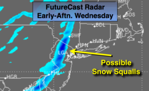
A polar vortex (frigid rotating airmass) will move from the Great Lakes today and into the Northeast Thursday. This airmass will be bitterly cold. An Arctic front will work in this afternoon. Scattered snow squalls are possible. Any squall can drop a quick inch of snow within minutes accompanied by gusty winds and low visibility. Please be aware it can go from sunny to a whiteout within moments from Noon to 6PM Today. Winds could gust between 40-50mph.
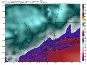
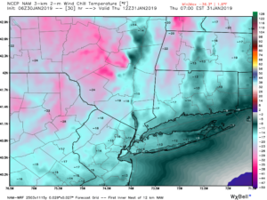
A bitter blast will once again grip the area on tonight through Friday as the polar vortex pushes it’s Arctic grip on the tri-state area. Readings will approach 0º along the coast tonight (2nd map above) & Thursday morning. Inland readings will be below zero. Wind Chills will reach -15º along the coast to -25º inland (last map above). This is life threatening cold. Please dress in layers as that tends to deaden the air in between the layers and in turn keep you warm.
The airmass will slowly moderate as high pressure works in from the West for the weekend. Skies will be mainly sunny. By Sunday it’ll feel like a heatwave!
You know where to find a no hype, no nonsense forecast.
Stay tuned.
Today:
Mostly sunny, windy and very cold. Scattered midday to afternoon snow squalls are possible. Highs in the 20s with readings plummeting during the day, reaching the teens by dark. Southwest to Northwest winds increasing to 15-30mph with gusts between 40-50mph during the afternoon.
Tonight:
Clear and bitterly cold. Lows 0º to 5º in the City and along the coast. 0º to -8º inland. Winds becoming West to Northwest at 15-25mph. Wind chills -5º to -15º along the coast. -15º to -25º inland.
Thursday:
Mostly sunny and frigid. Highs 8º to 14º. Wind chills near 0º along the coast, below zero inland.
Friday:
Mostly sunny and very cold. Highs in the mid 20s.
Saturday:
Sunny and not as harsh Highs around freezing.
Sunday:
Sunny and mild. Highs in the 40s.