Synopsis:
It’ll feel more like January today as high pressure over the plains supplies colder air from Canada. Winds will diminish with a mix of sun and clouds.
A weak low off Virginia along with upper level energy moving through the area Thursday morning will spark a few rain or snow showers. This won’t be a big deal. Another high will move in Thursday into Friday resulting in sunny and above average temperatures.
The models continue to show a low developing over the Ohio Valley on Friday. The upper low associated with the storm is in slow mode. Rain is not expected now until Saturday. The low will move over the region and into Eastern New England later Saturday. The strong Pacific jet stream continues to dominate and there is no supply of cold air, hence the rain and not snow.
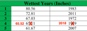
2018 will be know as-the year it rained. It was the 4th wettest year on record with 65.52″ of rain at Central Park! The average rainfall for the year is 49.94″. Records go back to 1869.
This pattern of no intrusion of Arctic air looks to continue for the first ten days of January. Sorry snow lovers, the wait continues.
You know where to find a no hype, no nonsense forecast.
Stay tuned.
A Happy New Year to all of my followers! All the best in 2019.
Today:
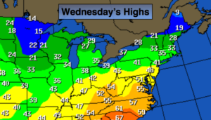
Sun and clouds. Colder. Highs around 40º.
Tonight:
Mostly cloudy with snow and rain showers. Lows in the mid 30s in the City, around 30º inland. Southeast winds at 5mph.
Thursday:
Scattered morning rain or snow showers, otherwise, partly sunny. Highs in the mid 40s.
Friday:
Sunny. Highs in the mid 40s.
Saturday:
On and off rain. Highs in the mid 40s.
Sunday:
Partly sunny. Highs in the mid 40s.
Keep it here for a no nonsense, no hype forecast.