Synopsis:
Conditions through Wednesday will feature abundant sunshine with temperatures near or just above normal as high pressure over the Southern states influences the region. It will be breezy through the period.
Low pressure over the Ohio Valley will move East and introduce the chance of late day rain Thursday. The rain will continue into the night as low pressure moves from the Ohio Valley to off our coastline. It now looks like only scattered showers are likely for Friday along with gusty winds as the storm intensifies off the coast. Highs on Thursday will be near average. Readings on Friday will be unseasonably chilly as colder air works in from the North.
Saturday will be chilly with gusty winds. High will be about ten degrees below the average high of the mid to upper 40s.
Stay tuned.
Keep it here for a no nonsense, no hype forecast…
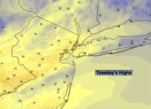
Tuesday:
AM Clouds to sun. Breezy and milder. Highs in the lower 60s. West winds at 15-25mph.
Tonight:
Partly cloudy. Lows around 50º in urban areas, the 40s inland. West to Northwest winds at 5-10mph
Wednesday:
Mostly sunny. Highs in the lower 60s.
Thursday:
Increasing clouds. Chance of late day rain. Highs in the upper 50s.
Friday:
Scattered showers. Becoming windy. Chilly. Highs in the mid to upper 40s.
Saturday:
Partly sunny, wind and cold. Highs in the mid to upper 40s. Wind chills in the upper 30s.