Synopsis:
A hot bubble of air will work East from the Central Plains today through Thursday. Temperatures will soar will into the 90s as three day heat wave takes hold.
The heat won’t be as intense on Friday as the hottest of air gets suppressed to the South.
Mainly sunny skies are expected through the week. No rain or storms are anticipated.
Saturday will feature relief as somewhat cooler air works in from the North. At the same time weak low pressure will be to our South. This system will be responsible for scattered afternoon and evening storms. It won’t be a washout.
Stay tuned.
Keep it here for a no nonsense, no hype forecast…
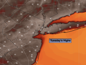
Tuesday:
Sunny. Hot. Highs in the mid 90s. Southwest winds at 10-20mph.
Tonight:
Mostly clear, muggy and warm. Lows around 80º in the City, the 60s and 70s inland. West to Southwest winds 8-12mph.
Wednesday:
Hazy, hot and humid. Highs in the upper 90s.
Thursday:
Sunny. Hot. Highs in the lower 90s.
Friday:
Mostly sunny. Highs in the upper 80s.
Saturday:
Partly sunny. Humid. Chance of afternoon storms. Highs in the mid 80s.