Synopsis:
High pressure will move from the Great Lakes to NJ this weekend. This will result in plenty of sun both days. Readings will be seasonal today (the lower 60s) and slightly below average on Sunday.
Monday will feature a pop in temperatures with highs getting into the 70s as a strong Southwest flow begins to take hold. Tuesday and Wednesday will be a Summer preview with highs reaching the 80s.
Our dry streak continues. Please use caution with flammables outdoors as the spread for wild fires is a concern.
Stay tuned.
Keep it here for a no nonsense, no hype forecast…
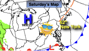
Saturday:
Mostly sunny. Breezy. Highs in the lower 60s. Northwest winds at 10-20mph with gusts to 30mph.
Tonight:
Mostly clear. Lows in the mid 40s in the City, the 30s inland. Diminishing North wind at 5mph.
Sunday:
Mostly sunny. Highs in the upper 50s.
Monday:
Partly sunny. Much warmer. Highs in the mid 70s.
Tuesday:
Partly sunny. Warm. Highs in the lower 80s.
Wednesday:
Partly sunny. Warm. Highs in the mid 80s.