Synopsis:
Today will feature a mix of sun and clouds along with a chilly breeze. Readings will be well below the average high for the date. Average highs are in the upper 50s. A freeze is likely for most of the area tonight as a Canadian high moves overhead. Wednesday will be chilly but bright.
Moderating temperatures are expected at the end of the week with a Southwest winds around an Atlantic high. Skies will be bright.
We’ll be flirting with 70º on Saturday under mainly sunny skies. We are in for a dry stretch.
Stay tuned.
Keep it here for a no nonsense, no hype forecast…
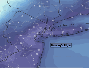
Tuesday:
Partly sunny. Breezy and cooler. Highs in the lower 50s. Northwest winds at 15-25mph with gusts to 30mph.
Tonight:
Mostly clear. Breezy and cold. Lows in the lower 30s in the City, the 20s inland. North winds at 8-15mph with gusts to 25mph.
Wednesday:
Sunny. Chilly. Highs around 50º.
Thursday:
Sunny. Highs in the mid to upper 50s.
Friday:
Mostly sunny. Milder. Highs in the mid to upper 60s.
Saturday:
Mostly sunny. Warm. Highs around 70º.