Synopsis:
A warm front will move through the region by midday today. Clouds will give way to partly sunny skies. It’ll be milder.
Saturday will feature a back door cold front over the NYC vicinity. Where this front sets up will determine your temperature. To the North and East of the front readings will be much cooler-in the 40s and 50s. To the West of the front readings will be in the 70s. This is quite typical for our region during the Spring. More clouds than sun is expected. A few showers can’t be ruled out later in the day.
Easter Sunday looks warm with a chance of showers by mid-morning through early afternoon. The sun will return later in the day. There will be some wet bonnets and Easter egg rolls.
It’ll be more seasonal on Monday and Tuesday with cooler air working in from Canada under a partly sunny sky.
Stay tuned.
Keep it here for a no nonsense, no hype forecast…
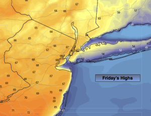
Friday:
Clouds to sun. Much milder. Highs in the mid to upper 60s. Winds becoming Southwest at 8-12mph.
Tonight:
Partly cloudy. Mild. Lows in the 50s throughout. Southwest winds at 5mph.
Saturday:
Mostly cloudy. A few showers possible later in the day. Temperatures will depend on location. Highs in the lower to mid 70s West to the 40s and 50s well North and East.
Easter Sunday:
Showers likely from mid-morning through early afternoon. The sun will return during the afternoon. Highs in the upper 60s.
Monday:
Partly sunny. More seasonal. Highs in the mid 50s.
Tuesday:
Partly sunny. Cooler. Highs in the lower 50s.