Synopsis:
March’s finale will feel more like early June. Readings will be more than twenty degrees higher than the average high for the date, which is in the mid 50s. A spotty shower can’t be ruled out, otherwise skies will be partly sunny. Wednesday- April’s debut will feature warm readings with a chance of showers in the afternoon as a cold front move in.
There will be a dramatic temperature swing on Thursday as high pressure over Southeastern Canada funnels in cooler air. Patchy drizzle is possible with the flow off the ocean along with a stationary front to our South.
Weak low pressure will be over the Northeast on Friday. More clouds than sun is expected with a chance of a few showers. It’ll be milder.
Saturday will be warmer but the threat of a shower still exists.
At this time Easter Sunday looks warm with a chance of showers later in the day. The egg rolls and bonnets should be dry for the morning hours!
Stay tuned.
Keep it here for a no nonsense, no hype forecast…
Tuesday:
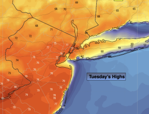
Partly sunny. Very warm. Spotty shower possible. Highs in the mid to upper 70s. Cooler at the coast. Southwest winds at 10-20mph with gusts to 25mph.
Tonight:
Mostly cloudy. Very mild. Lows in the 60s throughout. Southwest winds at 5-10mph.
Wednesday:
Mostly cloudy. Chance of afternoon showers. Warm. Highs in the mid 70s.
Thursday:
Cloudy. Patchy drizzle. Much cooler. Highs in the lower 50s.
Friday:
Mostly cloudy. A few showers possible. Mild. Highs in the mid 60s.
Saturday:
Mostly cloudy. A few showers possible. Warmer. Highs around 70º.