Synopsis:
It’ll be another cold night with most readings at the coast around freezing. Inland it’ll be a different story with well below freezing temperatures as a Canadian high pays a visit.
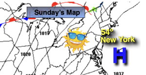
Sunday will be bright and seasonal with high pressure overhead.
A warm front will approach on Monday. A mix of sun and clouds is expected. It’ll be mild. Tuesday will be even warmer as the front moves to our North. A few showers are possible in the morning, otherwise skies will be partly sunny. Wednesday- April’s debut will feature warm readings with a chance of showers in the afternoon as a cold front move in.
There will be a dramatic temperature swing on Thursday as high pressure over Southeastern Canada funnels in colder air. At the same time showers can be expected as the front to our South continues to be throw moisture in our direction.
Stay tuned.
Keep it here for a no nonsense, no hype forecast…
Tonight:
Mostly clear. Cold. Lows near freezing for urban areas, the upper teens and 20s inland. Light North wind becoming South.
Sunday:
Sunny. Seasonal. Highs in the lower to mid 50s. Southwest winds at 8-15mph.
Monday:
Partly sunny. Mild. Highs in the lower to mid 60s.
Tuesday:
Spotty morning showers, otherwise partly sunny. Warmer. Highs in the mid 70s.
Wednesday:
Sun to clouds. Chance of afternoon showers. Warm. Highs in the mid 70s.
Thursday:
Cloudy with showers. Much cooler. Highs in the upper 40s.