Synopsis:
A cold front will move through early this morning with a few showers. Skies will become partly sunny during the afternoon. High temperatures will actually occur in the morning and then fall during the afternoon.
Tonight will be partly cloudy and much colder. Lows will be near freezing or below throughout the region.
Canadian air will move in for Saturday. It’ll be chilly along with abundant sunshine. Sunday will be bright and seasonal with high pressure overhead.
A warm front will approach on Monday. This will result in mostly cloudy skies. It’ll be mild. Tuesday will be even warmer as the front moves to our North. A few showers are possible.
Stay tuned.
Keep it here for a no nonsense, no hype forecast…
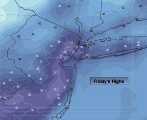
Friday:
Early AM showers to partly sunny skies. Early high in the 50s. Temps falling during the day. North winds at 15-25mph.
Tonight:
Partly cloudy. Much colder. Lows near freezing for urban areas, the 20s inland. North wind at 8-15mph.
Saturday:
Mostly sunny. Chilly. Highs in the mid 40s.
Sunday:
Sunny. Seasonal. Highs in the lower 50s.
Monday:
Mostly cloudy. Mild. Highs around 60º.
Tuesday:
Mostly cloudy. Few showers. Mild. Highs in the mid 60s.