Synopsis:
A cool front will move off the coast today. Rain will taper off from West to East later this morning. The sun will most likely make an appearance later this afternoon.
Tonight will be cold as Canadian air settles upon the region. Most area temperatures will be below freezing.
High pressure will move overhead on Tuesday. Sunny skies and cool temperatures are anticipated. Wednesday and Thursday will feature plenty of sun with readings slightly above the average highs of the lower 50s.
A cold front will move thorough Thursday night and Friday morning with a period of rain. Skies will become mostly sunny Friday along with seasonal readings.
Stay tuned.
Keep it here for a no nonsense, no hype forecast…
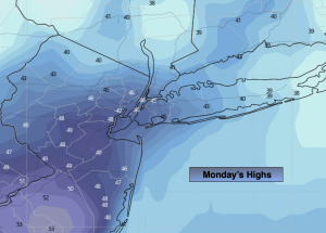
Monday:
Morning rain. Clouds will break for some sun later this afternoon. Cooler. Highs in the upper 40s. North 8-15mph.
Tonight:
Mostly clear. Colder. Lows around freezing in the City, the upper 20s inland. Northwest winds at 15-25mph.
Tuesday:
Sunny and cool. Highs in the upper 40s.
Wednesday:
Bright and seasonal. Highs in the mid 50s.
Thursday:
Partly sunny. Milder. Highs in the mid to upper 50s.
Friday:
AM Rain to mostly sunny skies. Highs in the mid 50s.