Synopsis:
A cool front will move toward the area this evening and tonight. Showers and isolated storms are possible. Showers will first affect the Northern counties late Sunday afternoon. Eventually the rain will move into the rest of the area from North to South during the evening hours. Local downpours are possible. A half inch to inch of rain is possible overnight. Leftover showers early Monday morning will give way to sunshine and cooler readings.
High pressure will move overhead on Tuesday. Sunny skies and cool temperatures are anticipated. Wednesday and Thursday will feature plenty of sun with readings slightly above the average highs of the lower 50s.
A cold front will move thorough Thursday night and Friday morning with a period of rain. Skies will become mostly sunny Friday along with seasonal readings.
Stay tuned.
Keep it here for a no nonsense, no hype forecast…
Tonight:
Showers and isolated storms. Lows in the 40s throughout. Winds becoming North at 5-10mph.
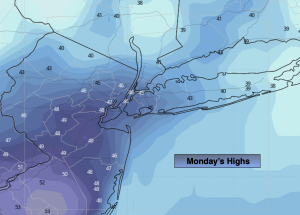
Monday:
Morning shower along the coast, otherwise becoming mostly sunny. Cooler. Highs in the upper 40s.
Tuesday:
Sunny and cool. Highs in the upper 40s.
Wednesday:
Bright and seasonal. Highs in the mid 50s.
Thursday:
Partly sunny. Milder. Highs in the mid to upper 50s.
Friday:
AM Rain to mostly sunny skies. Highs in the mid 50s.