Synopsis:
High pressure will be over the Eastern Seaboard through Friday resulting in tranquil conditions. Today, which is the last day of Winter, will be bright, but cool. Spring arrives tomorrow at 10:46am. Sun will give way to clouds. Temperatures will pop into the 50s!
A weak low will move through the region Friday night. A few showers are possible. A mix of sun and clouds is expected for Saturday. It’ll feel every bit like Spring. Sunday will be partly sunny and mild ahead of a cold front. Behind the front on Monday readings will be more seasonal under partly sunny skies.
Stay tuned.
Keep it here for a no nonsense, no hype forecast…
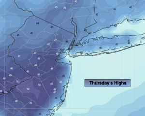
Thursday:
Partly sunny. Cool. Highs in the mid 40s. Southeast winds at 5-10mph.
Tonight:
Partly cloudy. Lows in the upper 30s in the City, near 30º inland. Southwest winds at 5mph.
Friday:
Sun to clouds. Mild. Highs in the mid 50s.
Saturday:
Few showers possible in the morning. A mix of sun and clouds. Mild. Highs in the upper 50s.
Sunday:
Partly sunny. Milder. Highs in the lower 60s.
Monday:
Partly sunny. More seasonal. Highs in the lower 50s.