Synopsis:
The wind and colder temperatures will be the story for today. A mix of sun and clouds is expected. Wednesday will feature abundant sunshine as high pressure moves off the East coast. Temperatures will be several degrees below average.
More seasonal temperatures are expected for Thursday, which is the last day of Winter!
Spring arrives Friday at 10:46am. Sun will give way to clouds. Temperatures will pop into the 50s!
A weak low will move through the region on Saturday with clouds. A few showers are possible. It doesn’t look like a washout.
Stay tuned.
Keep it here for a no nonsense, no hype forecast…
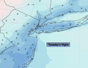
Tuesday:
Mostly sunny. Breezy and cooler. Highs in the lower 40s. West winds at 15-25mph with gusts to 30mph.
Tonight:
Partly cloudy. Cold. Lows in the mid 20s in the City, near 20º inland. Northwest winds at 10-20mph.
Wednesday:
Mostly sunny. Chilly. Highs around 40º.
Thursday:
Partly sunny. Seasonal. Highs in the mid to upper 40s.
Friday:
Sun to clouds. Highs in the mid 50s.
Saturday:
Mostly cloudy. Few showers possible. Highs in the lower 50s.