Synopsis:
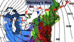
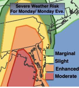
A deep Southerly flow will develop today ahead of a cold front. This will cause temperatures to pop into the 60s. Showers are possible just about anytime. Some of the rainfall will be heavy. An inch of rain will be common. It’ll be windy. Thunderstorms may accompany the front by evening. Some of the storms may turn severe, especially over Southern and Western sections (map above). The timing for the potential severe storms looks to be between 5pm-11pm.
It’ll be cooler on Tuesday and Wednesday with abundant sunshine as high pressure moves from the Ohio Valley to off the East coast.
More seasonal temperatures are expected for Thursday, which is the last day of Winter!
Spring arrives Friday at 10:46am. Sun will give way to clouds with readings just above the average high of the upper 40s.
Stay tuned.
Keep it here for a no nonsense, no hype forecast…
Monday:
Scattered showers and storms. Local downpours. Balmy. Windy. Highs in the lower 60s. Cooler at the coast. Southeast to South winds at 15-25mph with gusts 40-50mph, especially at the coast.
Tonight:
Showers and storms. Some of the storms maybe strong to severe (West). It all ends shortly after midnight. Windy. Lows in the 30s throughout. South to West winds at 15-25mph with gusts between 40-50mph.
Tuesday:
Mostly sunny. Cooler. Highs in the lower 40s.
Wednesday:
Mostly sunny. Chilly. Highs around 40º.
Thursday:
Partly sunny. Seasonal. Highs in the mid to upper 40s.
Friday:
Sun to clouds. Highs in the lower 50s.