Synopsis:
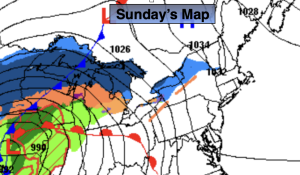
Sunday will feature more clouds as a warm front heads our way from the South. The wind will be off the colder Atlantic. Highs will be near the seasonal averages of the upper 40s.
On and off rain will develop toward midnight and continue through the overnight hours as the warm front moves in.
A deep Southerly flow will develop Monday ahead of a cold front. This will cause temperatures to pop into the 60s. Showers are possible just about anytime. Thunderstorms may accompany the front by evening. Some of the storms may turn severe, especially over Southern and Western sections. It’ll be windy.
It’ll be cooler on Tuesday and Wednesday with abundant sunshine as high pressure moves from the Ohio Valley to off the East coast.
More seasonal temperatures are expected for Thursday, which is the last day of Winter!
Stay tuned.
Keep it here for a no nonsense, no hype forecast…
Sunday:
Mostly cloudy. Highs in the upper 40s. Northeast to Southeast winds at 8-15mph.
Tonight:
Cloudy. On and off rain developing. Lows in the 40s throughout. East winds at 10-20mph.
Monday:
Scattered showers and storms. Balmy. Windy. Highs in the lower 60s. Cooler at the coast.
Tuesday:
Mostly sunny. Cooler. Highs in the lower 40s.
Wednesday:
Mostly sunny. Chilly. Highs around 40º.
Thursday:
Partly sunny. Seasonal. Highs in the mid to upper 40s.