Synopsis:
Winds will be busy today as low pressure moves from Northern New England to Nova Scotia. A mix of sun and clouds are expected with seasonal readings. Average high temperatures are in the upper 40s.
Sunday will feature more clouds as a warm front heads our way from the South. The wind will be off the colder Atlantic. Highs will be cooler than Saturday.
A deep Southerly flow will develop Monday ahead of a cold front. This will cause temperatures to pop into the 60s. Showers are possible just about anytime. Thunderstorms may accompany the front by evening. It’ll be windy.
It’ll be cooler on Tuesday and Wednesday with abundant sunshine as high pressure moves from the Ohio Valley to off the East coast.
Stay tuned.
Keep it here for a no nonsense, no hype forecast…
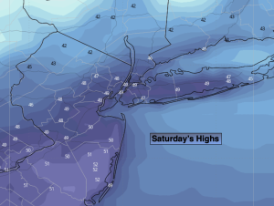
Saturday:
Mostly sunny. Windy. Highs in the upper 40s to lower 50s. West winds at 15-25 with gusts to 35mph.
Tonight:
Mostly clear early, clouding up late. Lows in the mid to upper 30s in the City, the 20s inland. Northwest to Northeast winds at 5mph.
Sunday:
Mostly cloudy. Highs in the mid 40s.
Monday:
Scattered showers and storms. Warm and windy. Highs in the lower 60s. Cooler at the coast.
Tuesday:
Mostly sunny. Cooler. Highs in the mid 40s.
Wednesday:
Mostly sunny. Chilly. Highs in the lower 40s.