Synopsis:
Today will be cool with an increasing Southwest wind. Readings will be more seasonal. The average high is in the mid to upper 40s. Sun will give way to clouds.
It’ll be a bright Saturday as high pressure moves overhead. Sunday will feature more clouds as a warm front struggles to move through.
A deep Southerly flow will develop Monday ahead of a cold front. This will cause temperatures to pop into the 60s. Showers are possible just about anytime. Thunderstorms may accompany the front by evening.
It’ll be cooler on Tuesday with abundant sunshine as high pressure moves toward the East coast.
Stay tuned.
Keep it here for a no nonsense, no hype forecast…
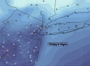
Friday:
Sun will give way to clouds. Becoming windy during the afternoon. Seasonal. Highs in the mid to upper 40s. Southwest to South winds increasing to 15-25mph with gust to 30mph later in the day.
Tonight:
Mostly cloudy early, clearing late. Breezy. Lows in the mid 30s in the City, around freezing inland. South to West winds at 15-25mph with gusts to 30mph.
Saturday:
Mostly sunny and pleasant. Highs in the lower 50s.
Sunday:
Mostly cloudy. Highs in the upper 40s.
Monday:
Scattered showers. Warm. Chance of evening thunderstorms. Highs in the lower 60s.
Tuesday:
Mostly sunny. Cooler. Highs in the mid 40s.