Synopsis:
Clouds and fog will eventually give way to partial sunshine Sunday afternoon. It’ll be much milder as we lose the effect of the colder ocean wind. Mild conditions will continue into Monday with high pressure off the Southeast coast. Temperatures will continue to rise through midweek. Finally, we’ll get some sunny days (it feels like it’s been weeks seen we’ve seen the sun). Highs may get into the 70s away from the colder Atlantic by Wednesday.
A cold front will move through the region Thursday midday. It’ll be mild to start. Showers will accompany the front and temperatures will drop during the afternoon.
Stay tuned.
Keep it here for a no nonsense, no hype forecast…
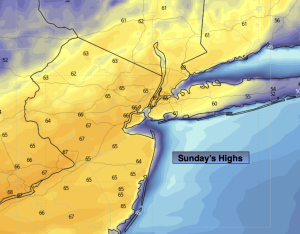
Sunday:
Clouds and morning fog, otherwise, becoming partly sunny later this afternoon. Milder. Highs in the mid 60s. Cooler at the coast. Southwest to West winds at 5-10mph.
Tonight:
Mostly clear. Lows in the 40s along the coast, the 30s inland. West winds at 5mph.
Monday:
Sunny. Mild. Highs in the mid 60s. Warmer inland, cooler at the coast.
Tuesday:
Mostly sunny. Highs in the upper 60s. Warmer inland, cooler at the coast.
Wednesday:
Partly sunny. Highs around 70º. Warmer inland, cooler at the coast.
Thursday:
A period of rain toward midday. Highs in the mid 60s. Temperatures falling during the afternoon.