Synopsis:
Clouds will thicken tonight. It won’t be as cold as last night.
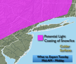
A warm front will approach on Tuesday. It maybe just cold enough at the onset for a light mix Tuesday morning inland. Rain will fall along the coast. Warmer air will work in and any frozen precipitation will go over to rain quite quickly. The potential exists for a light coating of snow and or ice in spots to the Northwest of I-95 during the mid to late morning and through early afternoon well North.
The front will clear the coast Wednesday morning. Mostly cloudy skies are expected with readings slightly above average.
A warm front will approach Thursday with scattered showers.
It’ll still be unsettled for Friday with a stationary front just to our South. Rain is likely during the morning. Cloudy skies will remain for the afternoon.
The best day of the bunch will be on Saturday. A Southwest wind should prevail around a Western Atlantic high. This should result in a boost in temperatures.
Stay tuned.
Keep it here for a no nonsense, no hype forecast…
Tonight:
Thickening clouds. Lows in the lower 30s in the City, the 20s North and West. Southeast winds at 5mph.
Tuesday:
Rain along the coast. Mix/rain inland depending on location going over to rain. Highs around 40º. East winds at 5-10mph.
Wednesday:
Mostly cloudy. Highs near 50º.
Thursday:
Mostly cloudy. Scattered showers. Highs in the upper 40s.
Friday:
Morning rain. Remaining cloudy. Highs in the upper 40s.
Saturday:
Partly sunny. Milder. Highs in the upper 50s.