Synopsis:
Canadian high pressure will settle over the region tonight and Monday with much colder conditions. Readings overnight will be well below freezing. Monday will be sunny and cold with most temperatures remaining at or below freezing.
A warm front will approach on Tuesday. It maybe just cold enough at the onset for a light mix Tuesday morning, especially inland. Warmer air will work in and any frozen precipitation will go over to rain quite quickly.
The front will clear the coast Wednesday morning. Mostly cloudy skies are expected with readings slightly above average.
A warm front will approach Thursday with scattered showers and milder temperatures.
It’ll still be unsettled for Friday with a stationary front just to our South. Showers are expected with slightly cooler readings than Thursday.
Stay tuned.
Keep it here for a no nonsense, no hype forecast…
Tonight:
Clear and cold. Lows in the lower 20s in the City, the teens North and West. North winds at 8-12mph with gusts to 20mph.
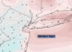
Monday:
Mostly sunny. Much colder. Highs around freezing. North to Southeast winds at 5mph.
Tuesday:
Mix/rain depending on location going over to rain. Highs around 40º.
Wednesday:
Mostly cloudy. Highs in the upper 40s.
Thursday:
Mostly cloudy. Scattered showers. Milder. Highs in the lower 50s.
Friday:
Mostly cloudy. Scattered showers. Highs in the upper 40s.