Synopsis:
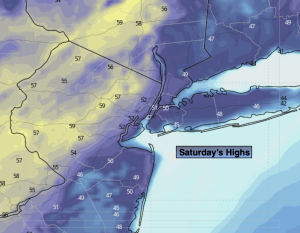
High pressure will move off the coast today allowing for a return flow of mild area. Areas of morning fog will give way to sunny skies. Highs will be a several degrees above the average high of the lower to mid 40s. Highs are expected to top 50º in many areas!
March’s debut on Sunday will feature a cold front moving through in the morning with rain or snow showers depending on location. The snow may coat the ground over the Northern 1/2 of the region by midday. The sun will return during the afternoon. . Temperatures will be below the average highs for the day by several degrees.
Monday will be dry as cold high pressure moves to the Northeast. A mix of sun and clouds are expected. It’ll be cold with most readings remaining at or below freezing.
A warm front will approach on Tuesday. It maybe just cold enough at the onset for a light mix Tuesday morning. Warmer air will work in any frozen precipitation will go over to rain during the afternoon.
The front will clear the coast Wednesday morning. Clouds will give way to sun with readings slightly above average.
Stay tuned.
Keep it here for a no nonsense, no hype forecast…
Saturday:
Mostly sunny. Milder. Highs in the 50s inland. The 40s at coastal locations. Light and variable winds.
Tonight:
Partly cloudy. Lows in the mid 30s in the City, the 20s North and West. Winds becoming North at 5-10mph.
Sunday:
Scattered rain or snow showers, otherwise becoming mostly sunny by mid-afternoon. Highs around 40º.
Monday:
Sun and clouds. Much colder. Highs around freezing.
Tuesday:
Mix going over to rain. Highs around 40º.
Wednesday:
Mostly cloudy. Highs in the mid 40s.