Synopsis:
Low pressure will pass to our South on Thursday. Much of the computer guidance suggests this weak system and most likely miss much of the area. A mix of sun and clouds are expected.
The sun will dominate on Friday along with chilly readings as high pressure moves overhead.
High pressure will move off the coast on Saturday along for a return flow of mild area. Highs will be a few degrees above the average high of the lower to mid 40s. A cold front will move through Sunday morning with flurries or snow showers. The sun will quickly return. Temperatures will fall to just below average.
Cold high pressure on Monday will keep readings at or below freezing. Low pressure in the Ohio Valley will throw a swath of snow Eastward. There is a low potential for some late day snow Monday afternoon. Much of latest computer guidance has shifted South with this system with a possible miss. Please continue to check back for further updates.
Stay tuned.
Keep it here for a no nonsense, no hype forecast…
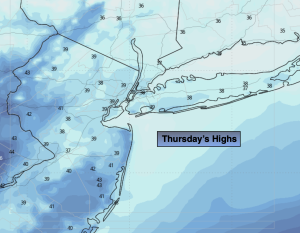
Thursday:
Clouds and sun. Highs around 40º. Northwest winds at 5-10mph.
Tonight:
Partly cloudy. Lows around 30º in the City, the teens and 20s North and West. North winds at 5mph.
Friday:
Sunny. Highs in the lower 40s.
Saturday:
Mostly sunny. Milder. Highs in the mid 40s.
Sunday:
AM Flurries. Mostly sunny. Highs around 40º.
Monday:
Thickening clouds. Potential for afternoon snow. Much colder. Highs around 30º.