Synopsis:
There will be a refreeze of slush and standing water tonight. Please exercise caution.
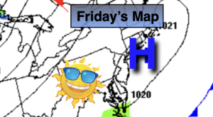
The sun will dominate on Friday along with seasonal readings as high pressure moves overhead.
High pressure will move off the coast on Saturday along for a return flow of mild area. Highs will be a several degrees above the average high of the lower to mid 40s. Highs are expected to top 50º in many areas!
A cold front will move through Sunday morning with flurries or snow showers. The sun will quickly return. Temperatures will fall to just below average.
Cold high pressure on Monday will keep readings around freezing. Over running moisture on top of the cold dense air at the surface will spread East through the Ohio Valley. Will this moisture dry up? Or will there be enough of a punch to cause some light snow? At this time JMW is calling for a low potential for some light snow Monday afternoon. Much of the computer guidance has shifted South with this system with a possible miss. Please continue to check back for further updates.
Tuesday at this time looks to be mostly cloudy and cold. We’ll be monitoring another swath of moisture will low pressure coming again from the West Tuesday night into Wednesday. Warmer air will be involved so whatever frozen precipitation falls should go over to rain.
Stay tuned.
Keep it here for a no nonsense, no hype forecast…
Tonight:
Partly cloudy. Lows around freezing in the City, the teens and 20s North and West. North winds at 5mph.
Friday:
Sunny. Highs in the lower 40s. Northeast to Southeast winds at 5mph.
Saturday:
Mostly sunny. Milder. Highs in the lower 50s.
Sunday:
AM Flurries. Mostly sunny. Highs around 40º.
Monday:
Thickening clouds. Low potential for afternoon snow. Much colder. Highs around freezing.
Tuesday:
Mostly cloudy. Highs in the mid to upper 30s.