Synopsis:
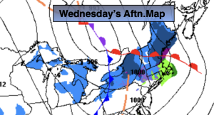
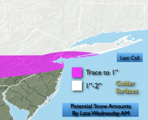
Quick hitting snow showers or a period of light snow is likely late tonight into Wednesday mid morning with a clipper passing well to the North. A trace to an inch is possible over central NJ and the Southern NYC vicinity. 1″-2″ is possible farther to the North. Areas to the South of the City may see a mix of rain or not much in the way of any precipitation.
Low pressure will pass to our South on Thursday. Much of the computer guidance suggests this weak system and most likely miss much of the area. I’ve included snow showers for Thursday afternoon and evening to the South of the City.
The sun will return on Friday along with chilly readings.
The weekend looks pleasant with high pressure in control. Temperatures will be near the seasonal averages of the lower to mid 40s.
Keep it here for a no nonsense, no hype forecast…
Tonight:
Becoming mostly cloudy. Light snow developing late. Remaining cloudy South. Lows in the upper 20s in the City, the teens and 20s North and West. West to South winds at 5-10mph.
Wednesday:
A few hours of morning snow showers or a period of light snow, otherwise mostly cloudy. Milder. Highs in the lower to mid 40s. Southwest winds at 10-15mph.
Thursday:
Mostly cloudy. Afternoon snow showers possible South. Highs around 40º.
Friday:
Mostly sunny. Highs in the upper 30s.
Saturday:
Mostly sunny. Milder. Highs in the mid 40s.
Sunday:
Mostly sunny. Highs in the lower 40s.