Synopsis:
Today will feature high pressure moving in. Sunny skies with readings around freezing are anticipated.
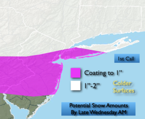
Quick hitting snow showers or a period of light snow is likely late tonight into Wednesday morning with a clipper. A coating is possible in spots with 1″-2″ possible North and West. Areas to the South of the City may see a mix of rain. The precipitation will end from mid to late morning from West to East.
Low pressure will approach from the Southwest Thursday. Snow/mix or rain depending on location is possible later in the day and a night. A light accumulation is possible, especially inland. The sun will return on Friday with near seasonal temperatures.
Saturday will be the best day of the bunch with abundant sun and tolerable readings.
Keep it here for a no nonsense, no hype forecast…
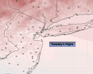
Tuesday:
Mostly sunny. Highs around freezing. Northwest winds at 10-20mph.
Tonight:
Becoming mostly cloudy. Light snow developing late. Remaining cloudy South. Lows in the upper 20s in the City, the teens and 20s North and West. West to South winds at 5-10mph.
Wednesday:
A few hours of morning snow showers or a period of light snow, otherwise mostly cloudy. Milder. Highs in the lower to mid 40s.
Thursday:
Mostly cloudy. Late day mix possible. Highs in the lower 40s.
Friday:
Becoming mostly sunny. Highs around 40º.
Saturday:
Mostly sunny. Highs in the lower 40s.