Synopsis:
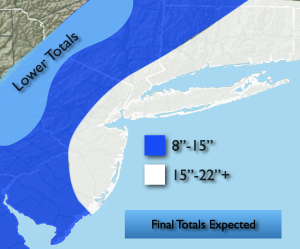
The nor’easter responsible for the blizzard for most of the area continues to move out to sea. Any snow this afternoon will come to an end. One to two feet of snow was common (map above). Much lower amounts fell well West.
Tonight will become party cloudy with diminishing winds. There will be a refreeze of standing water and slush.
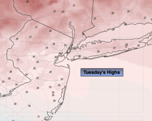
Tuesday will feature high pressure moving in. Sunny skies with readings around freezing are anticipated.
Quick hitting snow showers or a period of light snow is likely Wednesday morning with a clipper. A coating is possible in spots.
Low pressure will approach from the Southwest Thursday. Snow/mix or rain depending on location is possible later in the day and a night. A light accumulation is possible, especially inland. The sun will return on Friday with near seasonal temperatures.
Saturday will be the best day of the bunch with abundant sun and tolerable readings.
Keep it here for a no nonsense, no hype forecast…
Tonight:
Becoming party cloudy. Breezy. Lows in the 20s throughout. Northwest winds at 10-20mph.
Tuesday:
Mostly sunny. Highs around freezing. Northwest winds at 10-20mph.
Wednesday:
A few hours of morning snow showers or a period of light snow, otherwise mostly cloudy. Highs in the lower 40s.
Thursday:
Mostly cloudy. Late day mix possible. Highs in the lower 40s.
Friday:
Becoming mostly sunny. Highs around 40º.
Saturday:
Mostly sunny. Highs in the lower 40s.