Synopsis:
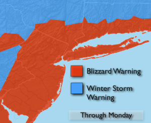
Blizzard Conditions are expected at times overnight into Monday morning.
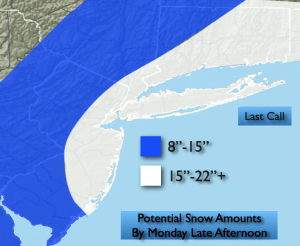
Bombogenesis will occur. This is a meteorological term. The “birth” of a bomb- a rapidly deepening storm of a drop in atmospheric pressure of 24mb with 24 hours (in this case it may happen within 12-18 hours!). A classic Nor’easter. The storm will bring heavy snowfall at rates of 1″-2″/hr especially along the I-95 corridor and to the coast, 40-60mph winds, thunder snow and whiteout conditions. The potential is there over a foot in many areas to possibly over 2o” in areas by the coast. There will be a sharp cutoff over Western areas with snowfall amounts. Where the heaviest snow bands set up is very hard to determine. There maybe some jackpot amounts scattered throughout the region with any one of these bands that sit over a region for a time. The snow will taper off later in the morning and early afternoon. Blowing and drifting will occur.
Moderate to major coastal flooding of 1′-3′ of inundation is possible at times of high tide. If your area is prone to tidal flooding please take precautions.
Tuesday will feature high pressure moving in. Sunny skies and just below seasonal average temperatures can be expected.
Scattered snow showers are possible Wednesday. Thursday will feature a warm front approaching. A mix to rain is possible later in the day and a night.
The sun will return on Friday with near seasonal temperatures.
Keep it here for a no nonsense, no hype forecast…
Tonight:
Blizzard conditions. Snow, heavy at times. Whiteout conditions. Lows in the upper 20s throughout. Northeast to North winds at 15-30mph gusts 40-55mph.
Monday:
Snow. Possibly heavy at times in the morning. Very windy. Snow will taper off during the late morning and afternoon. Highs in the mid 30s. Northwest winds at 15-30mph with gusts to 5omph.
Tuesday:
Mostly sunny. Highs in the upper 30s.
Wednesday:
Mostly cloudy with scattered snow showers. Highs near 40º.
Thursday:
Mostly cloudy. Late day mix possible. Highs in the lower 40s.
Friday:
Mostly sunny. Highs in the lower 40s.