Synopsis:
Cloudy skies with early spotty drizzle tonight. Readings for most will remain above freezing.
Clouds will continue to dominate on Saturday as weather systems remain weak over the region. It’ll be milder.
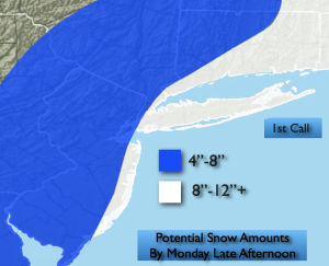
Sunday into Monday will feature a rapidly intensifying coastal storm. The latest computer guidance (including the European model) has shifted the storm farther West. This will result in upping the potential accumulation-dramatically. Rain and snow showers will begin midday Sunday and then become a steadier and heavier snow toward evening. The brunt of the storm will be Sunday night into Midday Monday. The snow will taper off from West to East Monday afternoon. 4″-8″ is possible with 8″-12″+ for coastal areas. These amounts will be adjusted with the incoming computer guidance the next two days. Winds will become an issue, especially along the coast. Gusts of 40-60mph are possible. Blizzard conditions are quite likely especially for Eastern Long Island.
Tuesday will feature high pressure moving in. Sunny skies and just below seasonal average temperatures can be expected.
Keep it here for a no nonsense, no hype forecast…
Tonight:
Mostly cloudy. Lows in the lower to mid 30s throughout. West winds at 5-10mph.
Saturday:
Mostly cloudy. Milder. Highs in the mid to upper 40s. West winds at 5-10mph.
Sunday:
Rain and snow showers changing to a steadier snow by evening. Heavy snow and high winds for most areas Sunday night. Highs in the mid to upper 30s.
Monday:
Snow. Possibly heavy at times in the morning along and East of I-95. Very windy. Snow will taper off during the afternoon. Highs around freezing.
Tuesday:
Mostly sunny. Highs in the upper 30s.