Synopsis:
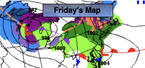
Rain will develop overnight and continue into Friday. Areas of freezing rain and sleet are possible North and West into the morning. Weak low pressure scooting to our South is responsible for the precipitation. This will all taper off later in the day.
Clouds will continue to dominate on Saturday as weather systems remain weak over the region. It’ll be milder.
Sunday into Monday will feature a rapidly intensifying coastal storm. The storm’s track is still in question. If it goes up the coast close enough to the region a significant snow is likely. If the storm tracks far enough offshore minor effects. Right now the potential exists for a light to possibly moderate snowfall. The storm will move farther offshore and the sun will return Monday afternoon. It is too early to give accumulations. Stay tuned.
Tuesday will feature high pressure moving in. Sunny skies and just below seasonal average temperatures can be expected.
Keep it here for a no nonsense, no hype forecast…
Tonight:
Light rain developing. Mix well inland. Lows in the lower to mid 30s throughout. Northeast winds at 5-10mph.
Friday:
Areas of rain. A mix possible North & West. Highs around 40º. Northeast winds at 5-10mph.
Saturday:
Mostly cloudy. Milder. Highs in the mid to upper 40s.
Sunday:
Some snow likely. Highs in the mid to upper 30s.
Monday:
Potential for AM snow, especially along the coast. Highs in the upper 30s.
Tuesday:
Mostly sunny. Highs in the upper 30s.