Synopsis:
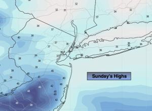
Sunday will feature developing low pressure to the Southwest. Any sun will give way to thickening clouds. Temperatures will be seasonal- around 40º.
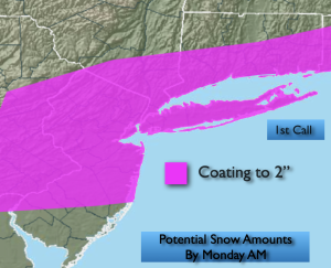
The latest computer guidance has nudged the Sunday night storm a bit farther North. The potential is there for a coating to two inches of snow for much of the region. This is a quick hitter, starting late evening and should clear the region well before sunrise Monday. Please stay tuned to the forecast as this is a low confidence forecast and changes will most likely be made to the potential snow amounts.
Presidents’ Day will feature increasing sunshine and near average temperatures as high pressure moves in from the West.
Tuesday will be bright and milder as high pressure over the Southeast pumps up a Southwesterly flow.
On Wednesday a stationary front will result in clouds and the possibility of rain showers. A wintry light mix is possible over Northern areas.
A partly sunny sky is expected on Thursday along with mild readings.
Keep it here for a no nonsense, no hype forecast…
Tonight:
Mostly clear. Lows around freezing along the coast, the teens and 20s inland. West winds at 5mph.
Sunday:
Thickening clouds. Highs in the upper 30s. Northeast to East winds at 5-10mph.
Presidents’ Day:
Partly sunny. Highs around 40º.
Tuesday:
Mostly sunny. Milder. Highs in the mid 40s.
Wednesday:
Mostly cloudy. Scattered showers. Highs in the lower 40s.
Thursday:
Partly sunny. Mild. Highs in the mid 40s.