Synopsis:
We’ll finally break the freezing mark today as a southwest wind develops around departing high pressure. Mostly cloudy skies are expected as a weak frontal boundary moves to our North. Scattered rain, snow or sleet showers are possible tonight. This won’t be a big deal.
The wind will be a factor mid to late week. Despite the wind Wednesday will feel like a heatwave with readings approaching 40º in many areas. Sunny skies and seasonably cold temperatures are expected through Thursday and Friday as the sun dominates.
The weekend will start off dry. Abundant sunshine is expected Saturday with tolerable temperatures. Sunday will feature developing low pressure to the Southwest. Where the storm tracks will determine if any precipitation will fall. One thing is for sure, there’s a lack of significant cold air to the North. It maybe just marginal for Wintry precipitation over parts of the region if the precipitation shield reaches this far North.
Stay tuned.
Keep it here for a no nonsense, no hype forecast…
Tuesday:
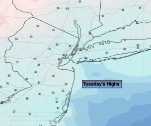
Mostly cloudy. Highs in the mid 30s. Southeast winds at 5-10mph.
Tonight:
Mostly cloudy. Scattered rain, snow or sleet showers depending on location. Lows in the lower 30s along the coast, the upper 20s to around freezing inland. Southeast to West winds at 5-10mph.
Wednesday:
Partly sunny. Highs in the upper 30s to around 40º.
Thursday:
Mostly sunny. Highs in the mid 30s.
Friday:
Sunny. Highs in the mid 30s.
Saturday:
Mostly sunny. Highs in the mid to upper 30s.