Synopsis:
We’ll be stuck in the freezer until further notice. Canadian air will continue to pour into our region the entire week. Temperatures will remain well below average and wind chills will be an issue. The snow on the ground will be with us for some time. Please use caution while traveling. A mix of sun and clouds is expected through Saturday. Stay warm.
There is a low potential of some coastal snow Sunday. The computer models do have low pressure developing off the Southeast coast. The storm tracks is in question. Will it head out to sea or affect our region? We’ll continue to monitor the latest computer guidance.
Stay tuned.
Keep it here for a no nonsense, no hype forecast….
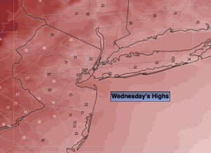
Wednesday:
Partly sunny. Cold. Highs in the lower to mid 20s. West winds at 8-12mph.
Tonight:
Partly cloudy. Lows in the lower along the coast, the single digits to -5º inland. West winds at 8-12mph. Wind chills 5º to -10º.
Thursday:
Mostly sunny. Bitter cold. Highs around 20º
Friday:
Mostly sunny. Bitter cold. Highs in the upper teens.
Saturday:
Partly sunny. Cold. Highs in the mid 20s.
Sunday:
Mostly cloudy. Low potential of some coastal snow. Highs in the mid 20s.