Synopsis:
Milder temperatures will be with us through the weekend.
High pressure will eventually move to the East coast through Thursday. Brighter skies are expected this afternoon and Thursday.
Friday will feature a warm front approaching. Rain will develop later in the morning and continue on and off into Saturday as a series of fronts affect the region. It’ll be in the 50s both days.
Sunday will be the better half of the weekend with the sun finally returning.
Our January thaw has arrived!
Stay tuned.
Keep it here for a no nonsense, no hype forecast…
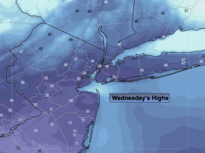
Wednesday:
Clouds to some sun. Milder. Breezy. Highs in the mid to upper 40s. West to Northwest winds at 15-25mph with gusts to 30mph.
Tonight:
Becoming mostly clear. Lows in the mid to upper 30s in the City, the upper 20s inland. West to Northwest diminishing winds at 5-10mph.
Thursday:
Sunny. Highs near 50º.
Friday:
Rain developing. Mild. Highs in the lower 50s.
Saturday:
On and off rain. Mild. Highs in the lower 50s.
Sunday:
Partly sunny. Breezy. Highs near 50º.