Synopsis:
Christmas Eve will feature partly cloudy skies. At midnight temperatures will be in the upper 30s in urban areas, near freezing inland.
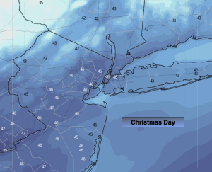
Christmas Day is looking dry at this time under a mostly cloudy sky. Temperatures will be above the average high for the holiday. The average high is in the lower 40s.
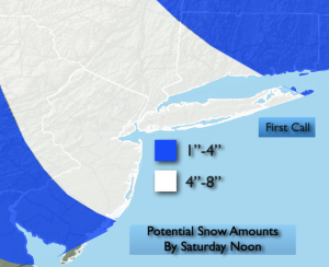
***Winter Storm Watch late Friday through Saturday Morning***Low pressure will move from the Midwest to off the Mid-Atlantic coast late Friday through Saturday. The latest computer guidance continues the scenario with high pressure over Southeastern Canada supplying enough cold air for accumulating snow Friday late afternoon, Friday night and Saturday morning. A mix is possible over central and Southern areas. Confidence continues to increase. The “first call” map is above. The potential for a 4″-8″ snowfall is there. We’ll continue to monitor the latest guidance and update the snow amount map accordingly.
Any precipitation on Saturday will taper off during the afternoon hours. Skies will remain cloudy.
A cold front will approach Sunday. The day will start off dry. A mix to rain is possible for Northern areas during the afternoon Sunday. Showers are expected elsewhere.
Monday morning the front will swing through with scattered showers. It’ll start off mild with highs near 50º. Temperatures will fall during the afternoon as the cold air filters. The drop in temperatures will be accompanied by a strong Northwest wind.
Stay tuned.
Keep it here for a no nonsense, no hype forecast…
Tonight:
Partly cloudy. Lows around freezing in the City, near 20º inland. Northwest diminishing winds becoming Southwest less than 5mph.
Christmas Day:
Mostly cloudy. Highs in the lower to mid 40s. West to Northwest winds at 15-25mph with gusts to 30mph.
Friday:
Snow/mix potential by late afternoon. Highs around 30º.
Saturday:
AM light snow/mix tapers off during the afternoon. Remaining mostly cloudy. Highs in the mid 30s.
Sunday:
Mostly cloudy. Mix possible North during the afternoon, showers elsewhere. Highs in the mid 40s.
Monday:
Morning showers, otherwise partly sunny, windy and turning colder. Early highs around 50º. Temperatures falling through the 40s and into the 30s.