Synopsis:
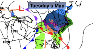
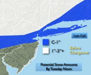
A warm front will approach the region today. Snow will mix with and change to rain at the coast before ending during the early afternoon. The potential for a light accumulations exists, mainly over Northwestern areas and the higher elevations. Potential snow amounts are above. Southern areas may not much in the way of any precipitation.
Christmas Eve will feature mostly sunny skies as high pressure slides in from the Great Lakes.
Christmas Day is looking dry at this time under a mostly cloudy sky. Temperatures will be just above average. The average high is in the lower 40s.
Low pressure will move from the Midwest to off the Mid-Atlantic coast Friday and Friday night. The latest computer guidance suggests that high pressure over Southeastern Canada will supply enough cold air for the potential of accumulating snow Friday afternoon and night. A mix is possible over central and Southern areas. Confidence at this time is at a low to moderate level.
Any precipitation on Saturday will taper off during the morning hours.
Stay tuned.
Keep it here for a no nonsense, no hype forecast…
Tuesday:
AM Snow and or rain depending on location. Remaining mostly cloudy. Highs around 40º. Southwest to West winds at 5-10mph.
Tonight:
Becoming partly cloudy. Lows in the mid 30s in the City, near 30º inland. West to Northwest winds increasing to 10-20mph with gusts to 30mph late.
Christmas Eve:
Mostly sunny. Highs in the lower to mid 40s.
Christmas Day:
Sun and clouds. Highs in the mid 40s.
Friday:
Snow/mix potential by afternoon. Highs in the mid 30s.
Saturday:
AM light snow/mix tapers off. Remaining mostly cloudy. Highs in the mid 30s.