Synopsis:
Tuesday will be bright but cold with high pressure over the Mid-Atlantic. Highs will flirt with freezing. We’ll come out of the freezer by Wednesday. In fact, by Thursday we’ll get into the lower 50s as high pressure moves off the Southeast coast.
Rain is likely Thursday night and early Friday morning with a cold front moving through. Temperatures on Friday will start off mild and drop into the 40s and 30s during the afternoon.
Saturday will be mostly sunny and cold.
Snow is not expected the next 7 days.
Stay tuned.
Keep it here for a no nonsense, no hype forecast…
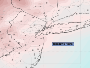
Tuesday:
Sunny. Highs in the lower 30s. Northwest to Southwest winds at 5-10mph.
Tonight:
Mostly clear. Not as cold. Lows in the lower 30s in the City, the teens & 20s inland. Southwest winds 5-10mph.
Wednesday:
Sunny. Not as harsh. Highs in the lower to mid 40s.
Thursday:
Sun to clouds. Milder. Highs in the lower 50s.
Friday:
Early morning rain. Becoming mostly sunny. Falling temps. Highs in the lower 50s, falling into the 40s & 30s.
Saturday:
Mostly sunny. Colder. Highs in the upper 30s.