Synopsis:
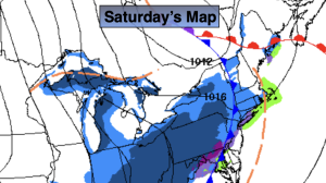
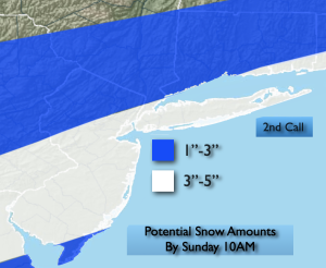
Saturday will start off with some sun but clouds will increase and thicken throughout the day. Snow is likely Saturday night and early Sunday morning with upper level energy and a weak wave of low pressure moving through. The snow looks to start just before midnight and taper off early to mid-morning Sunday. The potential for accumulating snow has increased and the amounts have gone up. The “2nd call” map is above. The jackpot zone looks to be central NJ to Long Island. These amounts will continue to be tweaked with the latest computer guidance.
The 2nd big story will be the bitter cold on Sunday. Temperatures will actually fall during the day into the 20s. The wind will add to the misery. We’ll be in the freezer on Monday as the Arctic air remains over the Northeast. Tuesday will be bright but cold with high pressure overhead. We’ll come out of the freezer by midweek.
Stay tuned.
Keep it here for a no nonsense, no hype forecast…
Saturday:
Thickening clouds. Highs in the upper 30s. Southwest winds 5-10mph.
Tonight:
Snow developing. Cold. Lows in the 20s throughout. West to Northwest winds at 5-10mph.
Sunday:
Early morning light snow, otherwise, partly sunny, windy and cold. Temperatures falling into the 20s.
Monday:
Mostly sunny, breezy and cold. Highs in the upper 20s.
Tuesday:
Sunny. Cold. Highs in the lower to mid 30s.
Wednesday:
Sunny. Not as harsh. Highs in the lower 40s.